Easter Island
Easter Island is a faraway Polynesian island in the southeastern Pacific Ocean. Its capital city is Hanga Roa.
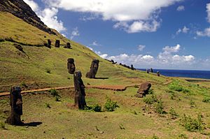
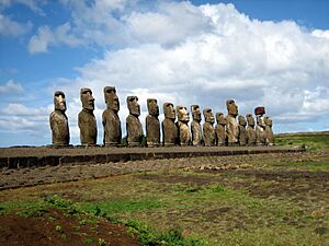
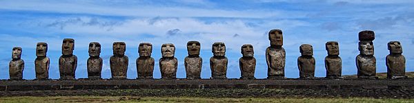
The island is famous for its 887 huge stone statues called Moai. These were carved by the early Rapa Nui people. Easter Island also has a large crater called Rano Kau. Inside this crater is a natural lake, one of only three sources of fresh water on the island.
Easter Island is a UNESCO World Heritage Site. A large part of the island is protected as the Rapa Nui National Park.
In the 1800s, diseases brought by European visitors and slave raids greatly reduced the island's population. Also, animals like rats and sheep, brought to the island, caused the loss of many native plants.
What's in a Name?
The name "Easter Island" was given by the first European visitor to record his arrival. This was a Dutch explorer named Jacob Roggeveen. He found the island on Easter Sunday (April 5), 1722. He was looking for "Davis Land" at the time. Roggeveen named it Paasch-Eyland, which means "Easter Island" in old Dutch. The island's official Spanish name, Isla de Pascua, also means "Easter Island."
Where is Easter Island?
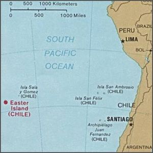
Easter Island is one of the most isolated islands in the world where people live. Its closest inhabited neighbor is Pitcairn Island. This island is about 1,931 kilometers (1,200 miles) to the west and has only about 50 people. The nearest part of a continent is in central Chile, near Concepción, about 3,512 kilometers (2,182 miles) away.
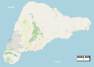
The island is shaped like a triangle. It is about 24.6 kilometers (15.3 miles) long and 12.3 kilometers (7.6 miles) wide at its widest point. Its total area is 163.6 square kilometers (63.2 square miles). The highest point on the island is 507 meters (1,663 feet) above sea level. There are three freshwater crater lakes on the island. These are at Rano Kau, Rano Raraku, and Rano Aroi. There are no permanent streams or rivers.
Climate and Weather
The weather on Easter Island is subtropical maritime. This means it's usually warm and humid. The coolest months are July and August, with temperatures around 18°C (64°F). The warmest month is February, with temperatures reaching up to 28°C (82°F). Winters are quite mild. April is the rainiest month, but it rains throughout the year.
Island Life and Nature
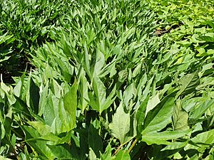
Easter Island, along with its neighbor Isla Salas y Gómez, is known as a special ecoregion. Long ago, the island was covered in subtropical moist forests. Studies of old plant remains show that many trees, shrubs, ferns, and grasses grew there.
A large, now extinct palm tree, Paschalococos disperta, was common. The Polynesian rat, brought by the first settlers, also played a part in the palm's disappearance. However, evidence shows that humans cut down many trees.
The toromiro tree (Sophora toromiro) also used to grow on Easter Island but is now extinct in the wild. Efforts are being made to bring it back to the island. With fewer trees, there was less rainfall. For almost a century, the island was used for sheep farming. By the mid-1900s, it was mostly covered in grassland.
Before humans arrived, Easter Island had huge seabird colonies. There were probably over 30 different species, making it one of the richest places for seabirds. Today, these colonies are not found on the main island.
History of Easter Island
Experts believe that Easter Island was first settled around 1200 CE. This was likely around the same time that Hawaii was settled. New dating methods have changed earlier ideas about when Polynesia was first settled.
Oral traditions say the first settlement was at Anakena. This spot offers good shelter and a sandy beach for canoes. However, some studies suggest other places were settled earlier.
The island was populated by Polynesians. They likely traveled in canoes or catamarans from islands like the Gambier Islands or the Marquesas Islands. Some theories suggest early Polynesian settlers might have come from South America. This idea comes from the presence of the sweet potato, a crop from South America, which was important in Polynesian culture. However, recent research suggests sweet potatoes might have spread naturally. When James Cook visited, a Polynesian crew member could talk with the Rapa Nui people. This shows their shared language roots.
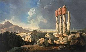
Old stories say the island once had a strong class system. A high chief, called an ariki, had great power. The most noticeable part of their culture was making the huge moai statues. Many believe these statues honored important ancestors or chiefs. People thought the dead helped the living with health and good fortune. In return, the living honored the dead with offerings. Most settlements were on the coast, and most moai faced inland, watching over their people.
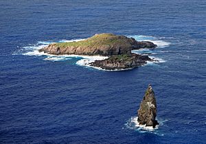
As the island became crowded and resources became scarce, warriors gained more power. The worship of ancestors changed to the Bird Man Cult. This cult believed that a human chosen through a competition could contact the dead. The god Makemake, who created humans, was important in this. Competitions for the Bird Man (Rapa Nui: tangata manu) began around 1760 and ended in 1878.
European Visitors
The first European to record visiting the island was Dutch sailor Jacob Roggeveen on April 5, 1722. His visit led to the death of about a dozen islanders.
Later, on November 15, 1770, two Spanish ships visited. The Spanish were amazed by the "standing idols," which were all upright then.
Four years later, in 1774, British explorer James Cook visited. He reported that some statues had fallen. He learned that the statues honored former high chiefs.
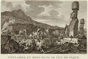
On April 10, 1786, French Admiral Jean-François de Galaup, comte de Lapérouse anchored at Hanga Roa. He made detailed maps of the bay and the island.
The 1800s
The 1860s brought terrible events to the island. In December 1862, slave raiders from Peru captured about 1,500 people. This was half of the island's population. Among those taken were the island's chief and people who could read the unique rongorongo script.
When the slave raiders were forced to return the people, they brought diseases like smallpox. This caused terrible epidemics on Easter Island and other islands. The population of Easter Island dropped so much that some people were not even buried.
Tuberculosis, brought by whalers, also killed many islanders. The population continued to shrink. By 1877, only 111 people lived on Easter Island. This meant much of the island's cultural knowledge was lost.
Alexander Salmon, Jr. helped bring back some workers. He eventually bought most of the land on the island. He worked to develop tourism and shared information with British and German explorers. He sold his land to the Chilean government on January 2, 1888.